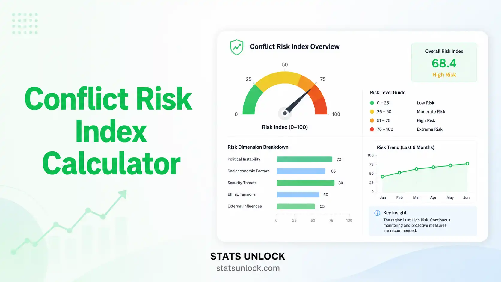
Conflict Risk Index Calculator
Free online human–wildlife conflict (HWC) risk index calculator. Quantify livestock depredation, crop raiding, and property damage hotspots across villages, grids, or seasons — and generate publication-ready output for ecology and conservation research.
⚙️ Study Configuration
📥 Data Input
Type or paste your data into two columns. One entry per line — names on the left, counts on the right. The two columns must have the same number of lines.
Supports .csv, .txt, .xlsx, .xls — headers detected automatically.
Add rows for each sampling unit. Numeric counts only.
🔍 Detailed Conclusion
▶ Run the analysis above to generate a personalised conclusion for your dataset.
📐 Technical Notes — Formula Derivation, Assumptions & Limitations
Extended Formula Derivation
The Conflict Risk Index is a normalized concentration metric derived from descriptive statistics. Beginning from a vector of conflict counts X = (x₁, x₂, …, xₙ), the index is:
CRI = x̄ / xmax = (1/n)·Σxi / max(x)
Equivalent forms include:
- Severity-weighted CRI: CRIw = Σ(wi·xi) / (n · max(w·x)), where wi is a severity weight (e.g., 1 = crop, 3 = livestock, 5 = human injury).
- Effort-standardised CRI: CRIe = (Σxi/Ei) / (n · max(x/E)), where Ei is the sampling effort for unit i.
- Pareto-aware concentration: The 80/20 metric P80 = (k/n) where k is the smallest count of top units whose cumulative incidents reach 80% of Σx.
Assumptions
- Sampling effort is standardised across units (or has been corrected via the effort-standardised form).
- Detection probability is comparable across units — under-reporting bias is not a confounder.
- The maximum value xmax is not a measurement artifact (e.g., one unit double-counted incidents).
- Non-negative integer counts (incidents cannot be fractional).
Limitations
- Sample-size sensitivity — CRI from n < 5 is unstable; report bootstrap CIs for n < 15.
- Outlier sensitivity — a single anomalously high xmax drives CRI down without changing the underlying conflict landscape; always inspect the ranked count distribution before interpretation.
- Temporal aggregation — annual CRI hides seasonal pulses; report seasonally where data permit.
- Spatial-scale dependence — CRI computed at the village scale and at the grid-cell scale will differ; always state the unit definition.
- Causality — CRI describes the burden but not the cause; pair with covariate models (logistic regression, MaxEnt, GLM) to identify drivers.
🧭 When to Use the Conflict Risk Index
Decision Checklist
- ✓ You have conflict-incident counts from a defined set of sampling units (villages, grid cells, ranches, months).
- ✓ You want to identify hotspots for prioritised management intervention.
- ✓ Your sampling effort is standardised, or you can correct for effort variation.
- ✓ You need a publication-ready, dimensionless metric for an ecology, conservation, or wildlife management journal.
- ✗ Do NOT use if your sampling effort differs greatly between units and you cannot adjust — first standardise to incidents-per-unit-effort.
- ✗ Do NOT use if you have only presence/absence data — use occupancy models instead.
- ✗ Do NOT use as the sole basis for management — pair with wildlife abundance, livelihood-cost, and stakeholder-perception data.
Real-World Examples
- Wolf–Livestock Conflict, Greater Yellowstone (USA) — Compensation records from 12 ranches in Montana's Paradise Valley, used to identify the 2–3 ranches driving most of the cattle losses for targeted livestock-guarding-dog deployment.
- Black Bear Property Damage, Florida (USA) — Bear damage incidents across 12 counties, used to prioritise bear-resistant trash-can grants in the highest-CRI counties.
- Mountain Lion–Pet Conflict, California (USA) — Predation incidents across 12 foothill zones, informing the design of public-awareness campaigns and livestock-shelter requirements.
- Elk–Crop Conflict, Colorado Rocky Mountains (USA) — Hay and alfalfa damage across 10 farms near Estes Park, used to prioritise game-fencing assistance.
- Coyote–Sheep Conflict, West Texas (USA) — Sheep depredation across 10 ranches, identifying the small subset of ranches accounting for 80% of total losses.
Sampling Design Guidance
- Minimum recommended n: 5 sampling units (CRI is interpretable but unstable; report bootstrap CIs).
- Reliable hotspot identification: 15–30 units.
- Robust spatial pattern testing: 50+ units (allows Moran's I, Getis–Ord G*).
- Time period: minimum 12 months to capture seasonal pulses; 2–3 years recommended for trend testing.
- Effort standardisation: if effort varies, report incidents-per-effort (e.g., per livestock-night, per ha-month).
Related Metrics — Decision Tree
Need a single number for conflict burden?  → Conflict Risk Index (CRI)
  → Want to weight severity differently? → CRI weighted form
  → Sampling effort varies among units?   → CRI effort-standardised form
Need to identify hotspots only?           → Getis–Ord G* / Moran's I
Need to predict where conflict will occur?→ Logistic regression / MaxEnt
Need to compare conflict between species? → Encounter Rate (per km) / RAI
Need to link conflict to wildlife density?→ Camera Trap RAI + CRI overlay
📖 How to Use This Tool — Step-by-Step Guide
STEP 1 — Enter Your Data
Three options: (a) paste comma-separated values into the textarea (default placeholder format: 52, 48, 55, 61, 47, ...), (b) use Column Entry mode to add labelled rows, or (c) upload a CSV/Excel file and select the count column. The default is comma-separated input.
STEP 2 — Choose a Sample Dataset
Five USA-based ecological scenarios are pre-loaded in the dropdown — Yellowstone wolf–cattle (default), Florida black bear, Texas coyote, California mountain lion, and Colorado elk. The first dataset loads on page render.
STEP 3 — Configure Analysis Settings
Edit the Group / Site Name (free-text, fully editable). Choose your Sampling Unit Type (village, grid, month, ranch, transect, county). Pick the Conflict Type. Set the Hotspot Threshold (1.0 / 1.5 / 2.0 SD above mean). 1.5 SD is the published default.
STEP 4 — Run the Analysis
Click ▶ Calculate Conflict Risk Index. The tool computes CRI = mean / max, identifies hotspots, runs a Pareto 80/20 analysis, and renders four visualizations.
STEP 5 — Read the Summary Cards
Green = LOW risk, amber = MODERATE, red = HIGH. The CRI Score and Risk Tier cards inherit the tier colour. The other four cards show hotspot count, total incidents, n, and CV.
STEP 6 — Read the Full Results Table
The table reports CRI, tier, n, sum, mean, median, max, min, SD, variance, CV, dispersion, hotspot cutoff, hotspot count, Pareto 80/20 count, and Pareto 80/20 percentage. Each row has a plain-language description.
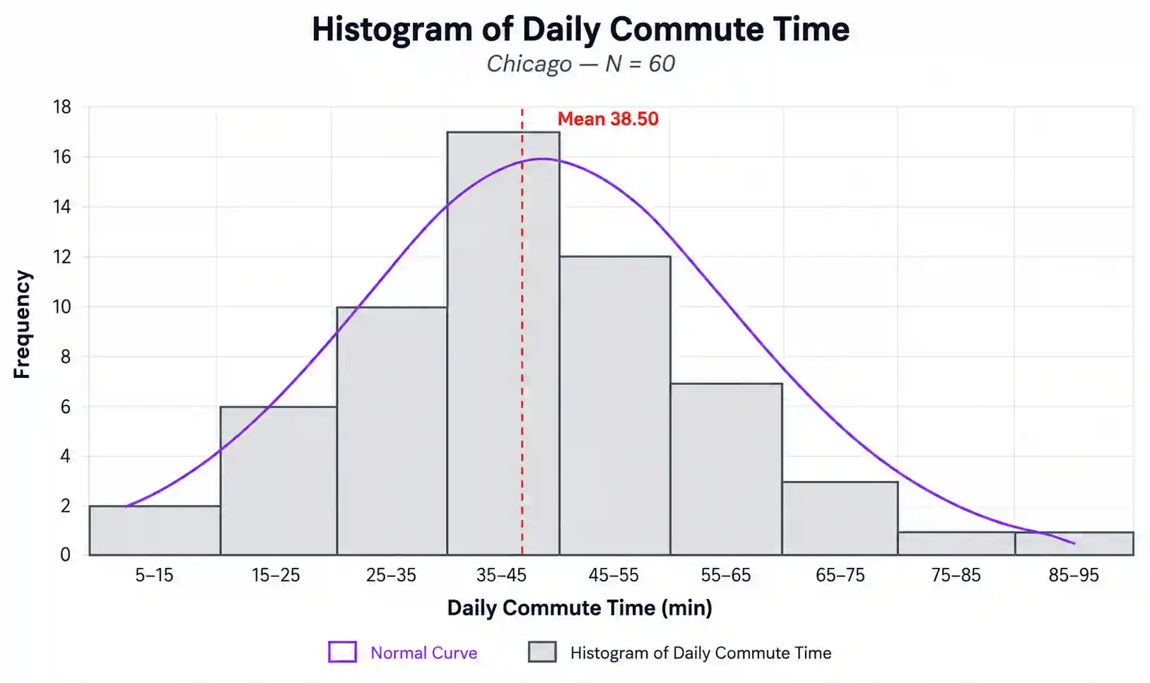
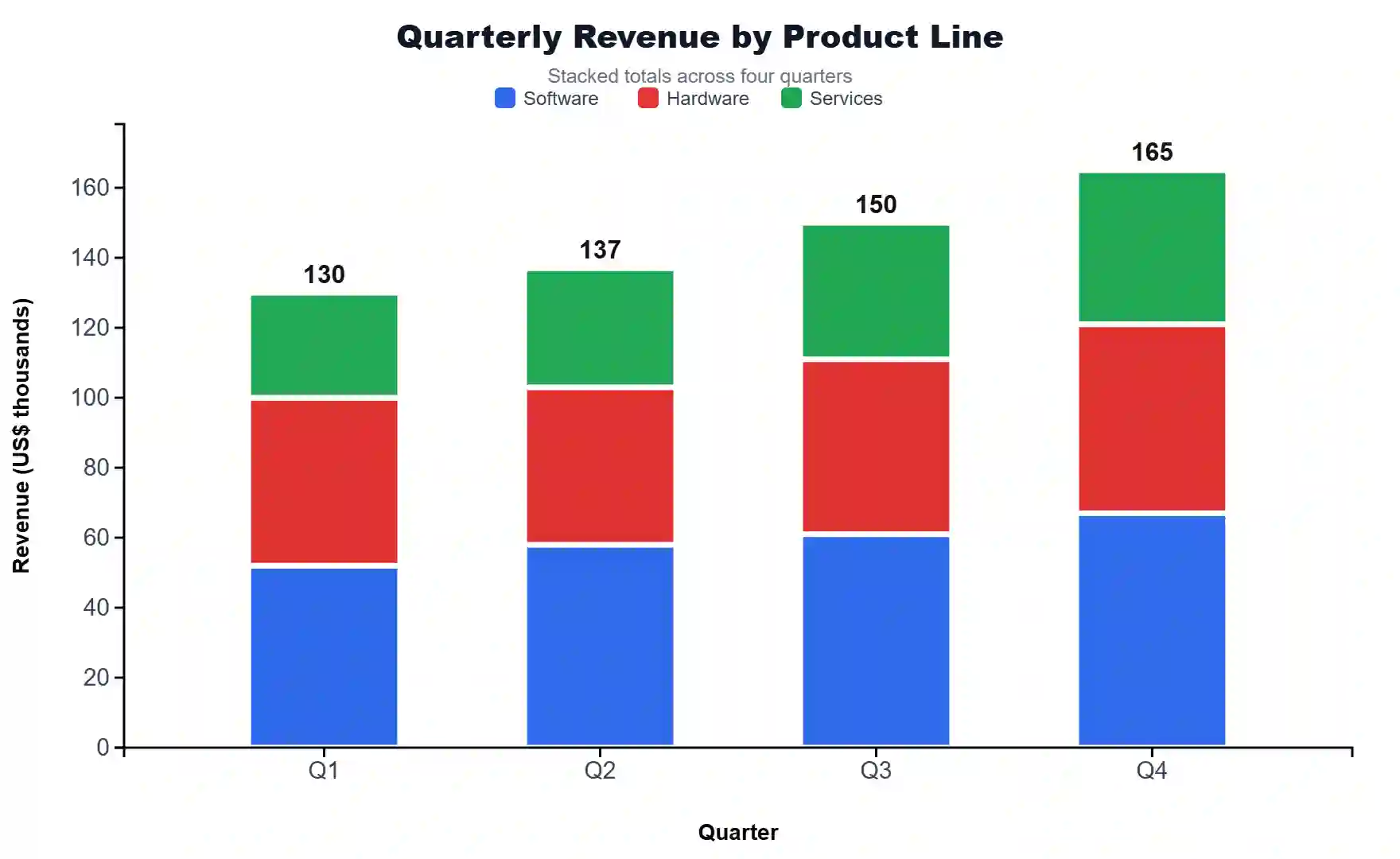
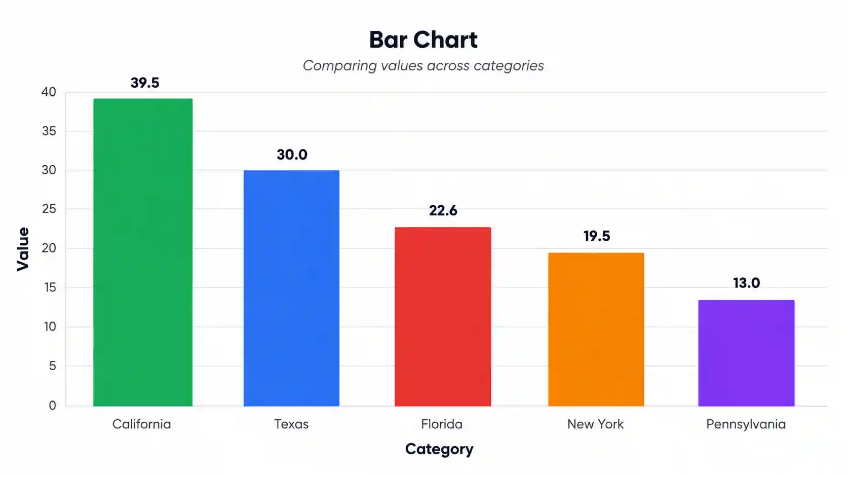
STEP 7 — Examine the Four Visualizations
Plot 1: Conflict count by unit (sorted, colour-coded by tier). Plot 2: Risk tier distribution (doughnut). Plot 3: Pareto cumulative percentage. Plot 4: Hotspot vs cold-spot scatter (point size proportional to count).
STEP 8 — Read the Interpretation
The Interpretation Results section provides 5 paragraphs covering what was found, magnitude, where conflict concentrates, practical vs ecological significance, and limitations. The Conclusion section adds 5 sub-blocks including a final take-home statement.
STEP 9 — Copy a Reporting Example
Choose the appropriate style for your audience: Ecology Journal (peer-reviewed), Thesis (graduate work), Plain-Language (policy / NGO), Conference Abstract, or LTER Monitoring. Click 📋 Copy to copy the auto-filled text.
STEP 10 — Export Your Results
Use Download Doc (.txt plain-text report) for archival, Download PDF (full A4 print-ready report) for distribution, or Copy Summary (clipboard) for quick sharing. The Research Poster Panel provides conference-ready content.
❓ Frequently Asked Questions
What is the Conflict Risk Index?
How is CRI calculated?
What CRI values indicate high risk?
What data do I need?
Can CRI compare across studies?
Is CRI suitable for tigers, elephants, and bears?
How many sampling units do I need?
Does CRI account for severity?
What is a conflict hotspot?
Can I use this for research publication?
📚 References
The following references support the methods and ecological context used in this Conflict Risk Index calculator, covering human–wildlife conflict, livestock depredation, and best practices in wildlife management and conservation biology.
- Treves, A., & Karanth, K. U. (2003). Human–carnivore conflict and perspectives on carnivore management worldwide. Conservation Biology, 17(6), 1491–1499. https://doi.org/10.1111/j.1523-1739.2003.00059.x
- Karanth, K. K., Gopalaswamy, A. M., DeFries, R., & Ballal, N. (2013). Patterns of human–wildlife conflicts and compensation: Insights from Western Ghats protected areas. Biological Conservation, 166, 175–185. https://doi.org/10.1016/j.biocon.2013.06.027
- Goswami, V. R., Vasudev, D., & Oli, M. K. (2015). The importance of conflict-induced mortality for conservation planning in areas of human–elephant co-occurrence. Biological Conservation, 187, 22–31. https://doi.org/10.1016/j.biocon.2015.03.016
- Manfredo, M. J., Vaske, J. J., & Teel, T. L. (2003). The Potential for Conflict Index: A graphic approach to practical significance of human dimensions research. Human Dimensions of Wildlife, 8(3), 219–228. https://doi.org/10.1080/10871200304310
- Vaske, J. J., & Shelby, L. B. (2010). Comparing two approaches for identifying acceptable levels of social impacts. Human Dimensions of Wildlife, 15(4), 319–328. https://doi.org/10.1080/10871209.2010.493196
- Treves, A., Wallace, R. B., Naughton-Treves, L., & Morales, A. (2006). Co-managing human–wildlife conflicts: A review. Human Dimensions of Wildlife, 11(6), 383–396. https://doi.org/10.1080/10871200600984265
- Inskip, C., & Zimmermann, A. (2009). Human–felid conflict: A review of patterns and priorities worldwide. Oryx, 43(1), 18–34. https://doi.org/10.1017/S003060530899030X
- Athreya, V., Odden, M., Linnell, J. D. C., Krishnaswamy, J., & Karanth, U. (2013). Big cats in our backyards: Persistence of large carnivores in a human-dominated landscape in India. PLoS ONE, 8(3), e57872. https://doi.org/10.1371/journal.pone.0057872
- Anand, S., & Radhakrishna, S. (2017). Investigating trends in human–wildlife conflict: Is conflict escalation real or imagined? Journal of Asia-Pacific Biodiversity, 10(2), 154–161. https://doi.org/10.1016/j.japb.2017.02.003
- Dickman, A. J. (2010). Complexities of conflict: The importance of considering social factors for effectively resolving human–wildlife conflict. Animal Conservation, 13(5), 458–466. https://doi.org/10.1111/j.1469-1795.2010.00368.x
- IUCN SSC Human-Wildlife Conflict Task Force. (2023). IUCN SSC Guidelines on human–wildlife conflict and coexistence (1st ed.). IUCN. https://www.iucn.org/resources/publication/iucn-ssc-guidelines-human-wildlife-conflict-and-coexistence
- Bombieri, G., Naves, J., Penteriani, V., Selva, N., Fernández-Gil, A., López-Bao, J. V., et al. (2019). Brown bear attacks on humans: A worldwide perspective. Scientific Reports, 9, 8573. https://doi.org/10.1038/s41598-019-44341-w
- Frontiers in Conservation Science. (2021). A framework for estimating human-wildlife conflict probabilities conditional on species occupancy. Frontiers in Conservation Science, 2, 679028. https://doi.org/10.3389/fcosc.2021.679028
- Acharya, K. P., Paudel, P. K., Neupane, P. R., & Köhl, M. (2016). Human–wildlife conflicts in Nepal: Patterns of human fatalities and injuries caused by large mammals. PLoS ONE, 11(9), e0161717. https://doi.org/10.1371/journal.pone.0161717
- R Core Team. (2024). R: A language and environment for statistical computing. R Foundation for Statistical Computing. https://www.R-project.org/