Fix Success Rate Calculator
Compute GPS and radio collar Fix Success Rate (FSR), missed fix rate, and collar performance metrics from your wildlife telemetry data — with charts, interpretation, and publication-ready output.
📥 Data Input
12 attempted-fix values
12 success values
💡 Each pair = one collar. Order must match between the two fields. Example: 52, 48, 55, 61, 47, ...
Accepts .csv, .txt, .xlsx, .xls
File:
Click a column to assign it as Attempted or Successful. Click again to reset.
| Collar ID | Attempted Fixes | Successful Fixes |
|---|
📊 Results Summary
Fix Success Rate Equation
The formula for Fix Success Rate (FSR) is:
- FSR: Fix Success Rate, expressed as a percentage (0–100%)
- Successful Fixes: Number of fix attempts that returned a valid GPS or radio location
- Attempted Fixes: Total number of scheduled fix attempts during deployment (derived from duty cycle × deployment days)
- Missed Fix Rate: 100% − FSR, the percentage of failed or no-location attempts
📋 Detailed Results Table
| Statistic | Value | Description |
|---|
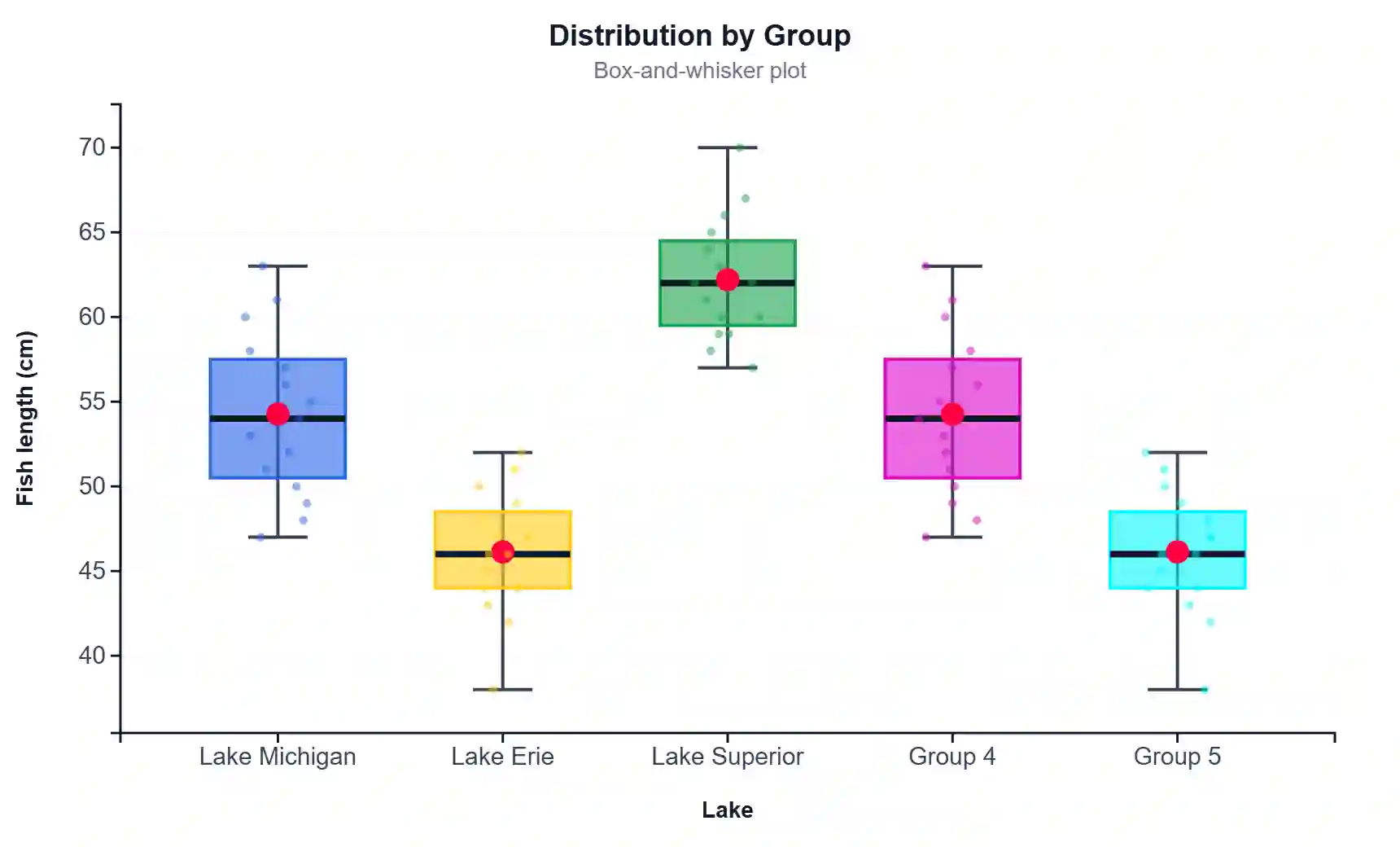
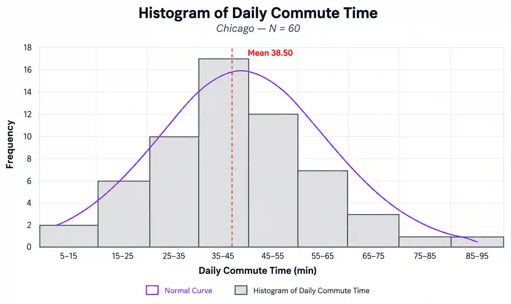
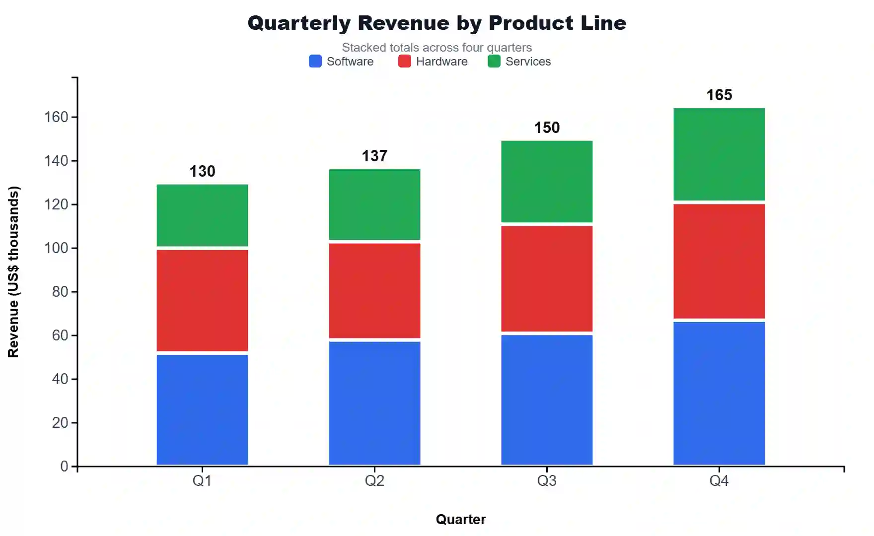
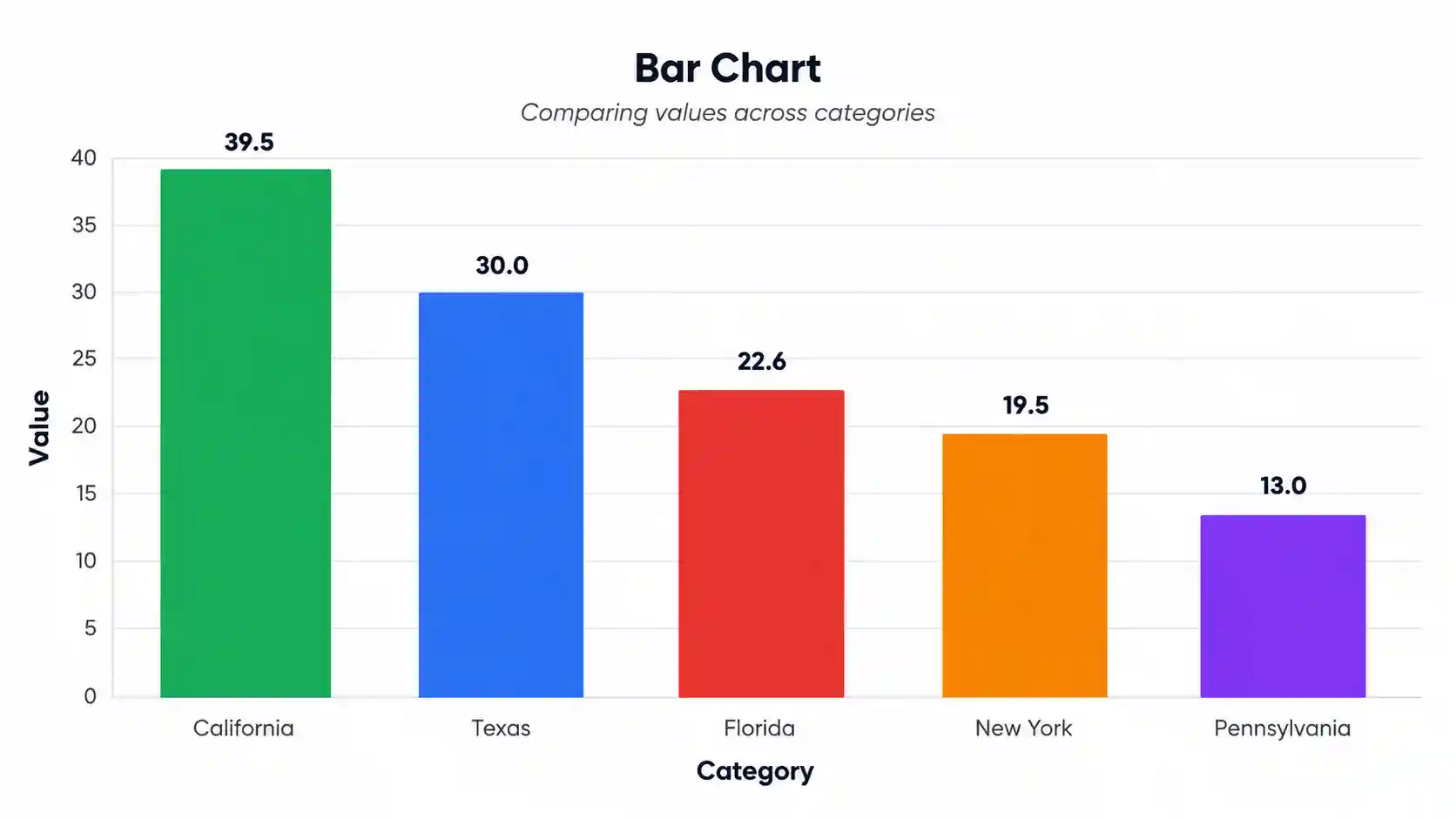
📈 Visualizations
🧭 Interpretation of Your Results
✍️ How to Write Your Results in Research
Five publication-ready templates — auto-filled with your computed values. Click 📋 Copy to use any of them.
🪧 Research Poster — Visual Science Communication
A complete print-ready research poster panel built from your results — ready for conferences and symposia.
🔍 Detailed Conclusion
❓ Frequently Asked Questions
Q1. What is Fix Success Rate (FSR) and when should I use it?
Fix Success Rate (FSR) is the percentage of successful GPS or radio collar location fixes out of the total number attempted during a deployment. It is the standard metric for quantifying collar performance and is required reporting in nearly every peer-reviewed wildlife telemetry study (e.g., Journal of Wildlife Management, Wildlife Society Bulletin, Movement Ecology). Use FSR whenever you need to summarise collar reliability, detect habitat-induced fix bias, or compare collars across deployments.
Q2. What data do I need to calculate Fix Success Rate?
You need two values per collar: the attempted fixes (scheduled attempts = duty cycle × deployment days) and the successful fixes (attempts that returned a valid latitude/longitude). Most collar manufacturers (Vectronic, Lotek, Telonics, ATS) report both fields in their data download. Use the comma-separated text tab, file upload (CSV/Excel), or manual table — whichever fits your data export.
Q3. What does a high vs low FSR mean for a study?
FSR > 90% is excellent — collars are performing as designed. FSR 80–90% is good but warrants checking for non-random missed fixes. FSR 60–80% is moderate and likely biases habitat selection or home-range estimates; correction factors are recommended. FSR < 60% is poor — Frair et al. (2010) recommend habitat-bias correction or weighting at this threshold.
Q4. How does FSR differ from PDOP filtering?
FSR is a performance metric — what fraction of attempts returned anything. PDOP (Position Dilution of Precision) is a quality metric — how accurate each successful fix is. A collar can have 95% FSR but high PDOP if many fixes are 2D or in poor satellite geometry. Always report both.
Q5. What are the assumptions and limitations of FSR?
FSR assumes: (a) the duty cycle is known and stable, (b) missed fixes are recorded by the collar, and (c) you have not screen-filtered the data before computing FSR. Limitations include: it does not distinguish habitat-induced failures from hardware failures, and it cannot detect bias by itself — you must look at habitat distribution of missed vs. successful fixes.
Q6. How many fixes do I need for FSR to be reliable?
For a single collar, ≥100 scheduled attempts gives a stable estimate. For multi-collar population FSR, ≥30 collars and ≥500 attempts per collar is standard. Confidence intervals widen substantially below these thresholds.
Q7. Can I compare FSR between species or sites?
Only if collar make/model, duty cycle, and habitat are standardised. Cross-study comparisons of raw FSR are not valid because manufacturer firmware differs. Use generalized linear mixed models (binomial family, logit link) with collar ID as a random effect for rigorous comparison.
Q8. How do I report FSR in a wildlife journal?
Always state: (1) FSR as a percentage, (2) numerator/denominator (e.g., 4,371/5,000), (3) the fix schedule (e.g., 1 fix per 2 h), (4) deployment duration, (5) collar make/model, and (6) the habitat. See Section 2.7 above for five worked publication templates.
Q9. Can I use this calculator for a thesis or peer-reviewed work?
This tool is suitable for educational use, thesis appendices, exploratory analysis, and project reports. For high-stakes peer-reviewed work, also verify with R packages (adehabitatLT, amt, move), which support habitat-bias correction. Cite this tool as: "StatsUnlock. (2026). Fix Success Rate Calculator. Retrieved from https://statsunlock.com."
Q10. My FSR seems unexpectedly low — what might have gone wrong?
Common causes: collar deployed in heavily forested or canyon terrain; collar oriented incorrectly on the animal (antenna pointing down); battery decline near end of deployment; data already filtered for screen-out fixes before counting; duty cycle changed mid-deployment but attempted total not updated; or incorrect column assignment in the upload tab. Re-check your raw data export and recompute.
🛠️ How to Use This Calculator
- Name your study area or project — type into the Study Area field (e.g., "Yellowstone Wolf GPS Study"). This name appears throughout your interpretation, conclusion, poster, and report templates.
- Set the group/species name — edit the "Group / Species Name" field. Default is "Gray Wolf"; change it to your species (e.g., "Mule Deer", "Cougar", "Caribou").
- Choose a sample dataset — pick one of five USA wildlife datasets to see how the tool behaves with real-world-like data, or replace with your own.
- Enter your data via one of three tabs — Type/Paste (comma-separated values, one number per collar), Upload (CSV/Excel with sheet + column picker), or Manual Table.
- Match the order — in the Type tab, the Nth attempted-fix value must correspond to the Nth successful-fix value. The two textareas must have the same count.
- Upload a file — in the Upload tab, select an Excel or CSV file. If multi-sheet, pick the sheet; then click two columns: one for Attempted, one for Successful. Use the preview to confirm column assignment.
- Click Calculate Fix Success Rate — the tool computes group FSR, per-collar FSR, missed-fix rate, and renders four colorful charts plus a full interpretation.
- Read the interpretation — five paragraphs explain the FSR tier (HIGH / MODERATE / LOW), habitat bias risk, sample-size adequacy, and recommended follow-up analyses.
- Copy a report template — five styles (Journal, Thesis, Plain-Language, Conference Abstract, Monitoring Report) are auto-filled with your values. Click 📋 Copy to grab any of them.
- Download or print — use Download Report for a plain-text summary, or Download PDF for a print-ready A4 layout including charts and conclusion.
📚 References
Key peer-reviewed references on Fix Success Rate, GPS collar performance, and wildlife telemetry bias correction (APA 7th edition).
- Frair, J. L., Fieberg, J., Hebblewhite, M., Cagnacci, F., DeCesare, N. J., & Pedrotti, L. (2010). Resolving issues of imprecise and habitat-biased locations in ecological analyses using GPS telemetry data. Philosophical Transactions of the Royal Society B, 365(1550), 2187–2200. https://doi.org/10.1098/rstb.2010.0084
- D'Eon, R. G., & Delparte, D. (2005). Effects of radio-collar position and orientation on GPS radio-collar performance, and the implications of PDOP in data screening. Journal of Applied Ecology, 42(2), 383–388. https://doi.org/10.1111/j.1365-2664.2005.01010.x
- Hebblewhite, M., & Haydon, D. T. (2010). Distinguishing technology from biology: a critical review of the use of GPS telemetry data in ecology. Philosophical Transactions of the Royal Society B, 365(1550), 2303–2312. https://doi.org/10.1098/rstb.2010.0087
- Cagnacci, F., Boitani, L., Powell, R. A., & Boyce, M. S. (2010). Animal ecology meets GPS-based radiotelemetry: a perfect storm of opportunities and challenges. Philosophical Transactions of the Royal Society B, 365(1550), 2157–2162. https://doi.org/10.1098/rstb.2010.0107
- Recio, M. R., Mathieu, R., Denys, P., Sirguey, P., & Seddon, P. J. (2011). Lightweight GPS-tags, one giant leap for wildlife tracking? An assessment approach. PLoS ONE, 6(12), e28225. https://doi.org/10.1371/journal.pone.0028225
- Lewis, J. S., Rachlow, J. L., Garton, E. O., & Vierling, L. A. (2007). Effects of habitat on GPS collar performance: using data screening to reduce location error. Journal of Applied Ecology, 44(3), 663–671. https://doi.org/10.1111/j.1365-2664.2007.01286.x
- Cain III, J. W., Krausman, P. R., Jansen, B. D., & Morgart, J. R. (2005). Influence of topography and GPS fix interval on GPS collar performance. Wildlife Society Bulletin, 33(3), 926–934. https://doi.org/10.2193/0091-7648(2005)33[926:IOTAGF]2.0.CO;2
- Forrest, S. W., Pagendam, D., Bode, M., Drovandi, C., Potts, J. R., Perry, J., Vanderduys, E., & Hoskins, A. J. (2024). Simulating animal movement trajectories from temporally dynamic step-selection functions. Methods in Ecology and Evolution, 15(12), 2356–2371. https://doi.org/10.1111/2041-210X.14248
- Calenge, C. (2006). The package "adehabitat" for the R software: A tool for the analysis of space and habitat use by animals. Ecological Modelling, 197(3–4), 516–519. https://doi.org/10.1016/j.ecolmodel.2006.03.017
- Signer, J., Fieberg, J., & Avgar, T. (2019). Animal movement tools (amt): R package for managing tracking data and conducting habitat selection analyses. Ecology and Evolution, 9(2), 880–890. https://doi.org/10.1002/ece3.4823
- Kranstauber, B., Smolla, M., & Scharf, A. K. (2024). move2: R package for processing animal movement data. Methods in Ecology and Evolution, 15(8), 1335–1342. https://doi.org/10.1111/2041-210X.14333
- Tomkiewicz, S. M., Fuller, M. R., Kie, J. G., & Bates, K. K. (2010). Global positioning system and associated technologies in animal behaviour and ecological research. Philosophical Transactions of the Royal Society B, 365(1550), 2163–2176. https://doi.org/10.1098/rstb.2010.0090
- Gula, R., & Theuerkauf, J. (2013). The need for standardization in wildlife science: home range estimators as an example. European Journal of Wildlife Research, 59(5), 713–718. https://doi.org/10.1007/s10344-013-0726-7