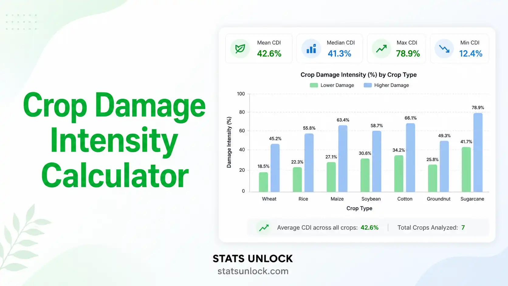
Crop Damage Intensity Calculator
Quantify the percentage of cultivated area damaged by wildlife — across plots, villages, and seasons. Built for human-wildlife conflict researchers, agricultural extension officers, and conservation managers working on crop raiding, wildlife depredation, and livelihood impact assessment.
Enter Your Crop Damage Data
Enter the % of each plot damaged by wildlife. Use commas (default). Newlines also accepted. Values must be 0–100.
Supports .csv, .txt, .xlsx, .xls — headers detected automatically. Pick the Plot Label column (text) and the Damage % column (numeric).
Add up to 30 rows manually. Click a cell to edit.
| Plot Label | Damage % |
|---|
Analysis Configuration
🎯 Detailed Conclusion
📐 Technical Notes — Formula Derivation, Assumptions & Limitations
Extended Formula Derivation
The Crop Damage Intensity index follows the standard formulation used in human-wildlife conflict literature (Naughton-Treves, 1998; Hill, 2000; Sitati et al., 2003). Per plot:
CDIi = (Di / Ai) × 100
The plot-level summary uses the arithmetic mean. For weighted analyses (where plot sizes vary substantially), the area-weighted CDI is preferred:
CDIweighted = ∑(Di) / ∑(Ai) × 100
This calculator also returns the standard deviation (SD), standard error (SE = SD / √n), 95% confidence interval (CI = mean ± 1.96 × SE), median, IQR, and coefficient of variation (CV = SD / mean × 100).
Assumptions
- Damage estimates are independent across plots
- Damage is correctly attributed to wildlife (not disease, drought, or theft)
- Plot boundaries and total area were measured before damage assessment
- Observer training and damage definition were standardised across surveyors
- The sample frame is representative of the target population of fields
Limitations
- Visual estimates of % damaged area are observer-dependent — inter-rater reliability ≥ 0.80 (Cohen's κ) is recommended
- Recall bias affects retrospective farmer interview methods more than direct measurements
- CDI does not directly measure economic loss — multiply by yield × price for monetary impact
- Mean CDI is sensitive to outlier plots (one 100% loss can dominate small samples)
- Cannot identify the species responsible without independent evidence (camera traps, tracks, dung, direct observation)
- Does not separate first-time damage from re-damaged plots without temporal data
🎯 When to Use This Tool
Decision Checklist
- ✓ You have measured or estimated damaged-area-per-plot from field surveys
- ✓ You want a single comparable figure for HWC reports, papers, or compensation programmes
- ✓ Your sampling effort is standardised (same protocol across plots and surveyors)
- ✓ You need a publication-ready metric for journals such as Oryx, Biological Conservation, or Human Dimensions of Wildlife
- ✗ Do not use if damage was caused by drought, disease, or non-wildlife factors
- ✗ Do not use raw CDI to compare studies that used different damage definitions
- ✗ Do not use for economic loss without multiplying by yield and farmgate price
Real-World Examples (US Contexts)
- Iowa Corn Belt — measuring white-tailed deer damage to standing corn before harvest, used to inform USDA Wildlife Services damage management
- Texas Sorghum & Cotton — quantifying feral hog damage across South Texas farms for state-level depredation policy
- California Almond Orchards — assessing crow, starling, and squirrel damage in Central Valley orchards
- Wisconsin Dairy Corn — sandhill crane damage to seedling corn for crop insurance claim review (Wisconsin DNR)
- Florida Sweet Corn — black bear damage to sweet corn fields adjacent to Ocala National Forest
Sampling Design Guidance
- Minimum 30 plots per village or landscape unit for stable estimates
- 50–100 plots ideal for inter-village or inter-county comparison
- Survey across the full crop calendar — sampling only pre-harvest underestimates total damage
- Replicate in ≥ 2 seasons for trend detection
- Use stratified random sampling by distance-to-forest-edge for HWC studies
- Inter-rater reliability ≥ 0.80 (Cohen's κ) before deploying multiple surveyors
Related Metrics — Decision Tree
Need overall % loss? → Crop Damage Intensity (CDI) ← THIS TOOL Need event count? → Crop Raiding Frequency Need economic loss? → Loss = CDI × yield × price Need risk-mapping for plots? → Hotspot / kernel density Need species attribution? → Camera trap RAI / sign surveys Need driver analysis? → GLMM with plot-level covariates
📖 How to Use This Tool — Step by Step
- Enter Your Data — Use the Type tab for paste, Upload tab for CSV/Excel, or Manual tab for direct entry. Default format is comma-separated, e.g.
52, 48, 55, 61, 47. - Choose a Sample Dataset — Five US wildlife examples are pre-loaded (deer, hog, crow, crane, bear).
- Configure Settings — Set Study Area, Wildlife Species, Crop Type, Season, Plot Unit, and Severity Threshold System.
- Run the Analysis — Click "Calculate Crop Damage Intensity". The tool computes Mean CDI, SD, SE, 95% CI, median, IQR, and severity class breakdown.
- Read Summary Cards — Green = low damage, amber = moderate, red = high, dark red = severe.
- Read the Detailed Statistics Table — Each row explains what each statistic means in HWC research terms.
- Examine the Four Visualisations — Sorted plot bars, severity donut, histogram, and cumulative damage curve each tell a different part of the story.
- Read the Detailed Interpretation — Five plain-English paragraphs auto-filled with your numbers.
- Copy a Reporting Example — Six pre-formatted templates: ecology journal, thesis, policy brief, conference abstract, monitoring report, and full research poster.
- Export Your Results — Download .txt for a Word-ready report, or PDF for printing/sharing.
Worked example: A 47-plot survey of Iowa cornfields adjacent to Saylorville Lake yielded a mean CDI of 28.4 ± 4.1% (95% CI: 20.4–36.4%), with 34% of plots in the severe class (>60% damage). White-tailed deer were identified as the primary species via track surveys.
❓ Frequently Asked Questions
Q1. What is crop damage intensity and when should I use it?
Crop Damage Intensity (CDI) is the percentage of cultivated area damaged by wildlife, expressed per plot, household, or village. It is the standard quantitative metric in human-wildlife conflict (HWC) research and is used wherever damaged-area-per-field is recorded. Use CDI when you need a single comparable figure for reports, mapping, compensation programmes, or comparative landscape analyses.
Q2. What data do I need to calculate crop damage intensity?
Damage as a percentage per plot. Most field studies record total field size and damaged area, then calculate the percent damaged for each plot. Paste the percentages directly, upload a CSV/Excel sheet, or use the column-entry table to label each plot. A minimum of 30 plots is recommended for stable village-level estimates.
Q3. What does a high vs low CDI value mean?
Under 10% indicates background damage from rodents and birds. 10–30% reflects regular conflict, often from deer or primates. 30–60% indicates serious wildlife pressure (hogs, elephants in some regions). Above 60% is near-total crop loss — a livelihood and conservation emergency that triggers immediate compensation review and management response.
Q4. How does CDI differ from crop raiding frequency?
CDI measures the magnitude of damage (how much). Raiding frequency measures the count of events (how often). A field can have low frequency but very high intensity (one elephant visit destroys 80%) or high frequency but low intensity (rodents nibble nightly but remove only 5% total). Always report both for a complete picture.
Q5. What are the assumptions and limitations of CDI?
CDI assumes damage is measurable, attributable to wildlife, and not confounded with disease, drought, or management failures. Limitations include observer bias in visual estimates, recall bias in farmer interviews, and difficulty assigning damage to specific species without independent evidence (tracks, dung, camera footage).
Q6. How much sampling effort do I need for CDI to be reliable?
Minimum of 30 surveyed plots per village; 50–100 plots ideal for landscape comparison. Sample across the full crop calendar — pre-harvest assessments alone underestimate cumulative damage. Replicate surveys in at least three villages and two seasons before drawing policy conclusions.
Q7. Can I compare CDI between sites or seasons?
Yes — but only if you used identical protocols (same crop stage, same damage definition, same observer training). Standardise the damage thresholds before comparison. For unequal sample sizes, use weighted means or bootstrap resampling. Avoid comparing farmer-interview CDI against field-measured CDI — the methods produce systematically different numbers.
Q8. How do I report CDI in a research paper?
Report mean CDI ± SE, sample size n, the percent of plots in each damage class, and the dominant wildlife species. Example: "Mean crop damage intensity at the study site was 28.4 ± 4.1% (n = 47 plots), with 34% of plots in the severe damage class attributable to wild boar." See the How to Write Your Results section above for six full templates including a research poster.
Q9. Can I use this calculator for published research or a thesis?
Yes — calculations follow standard HWC methodology used in peer-reviewed journals such as Oryx, Biological Conservation, and Human Dimensions of Wildlife. Verify final values in R or Excel using the same input data and cite the tool: "StatsUnlock. (2025). Crop Damage Intensity Calculator. Retrieved from https://statsunlock.com".
Q10. My CDI value seems unexpectedly high — what might have gone wrong?
Common causes: a single outlier plot pulling up the mean, mixing damage from non-wildlife sources, failing to standardise plot size, or treating cumulative seasonal damage as a single event. Always plot the histogram (provided in the visualisation) and inspect the distribution before interpreting the mean.
📚 References
The following peer-reviewed references support the methods used in this crop damage intensity calculator, covering human-wildlife conflict, crop raiding analysis, and best practices in wildlife damage assessment.
- Naughton-Treves, L. (1998). Predicting patterns of crop damage by wildlife around Kibale National Park, Uganda. Conservation Biology, 12(1), 156–168. https://doi.org/10.1046/j.1523-1739.1998.96346.x
- Hill, C. M. (2000). Conflict of interest between people and baboons: Crop raiding in Uganda. International Journal of Primatology, 21(2), 299–315. https://doi.org/10.1023/A:1005481605637
- Sitati, N. W., Walpole, M. J., Smith, R. J., & Leader-Williams, N. (2003). Predicting spatial aspects of human-elephant conflict. Journal of Applied Ecology, 40(4), 667–677. https://doi.org/10.1046/j.1365-2664.2003.00828.x
- Conover, M. R. (2002). Resolving human-wildlife conflicts: The science of wildlife damage management. CRC Press. https://doi.org/10.1201/9781420032581
- Treves, A., & Karanth, K. U. (2003). Human-carnivore conflict and perspectives on carnivore management worldwide. Conservation Biology, 17(6), 1491–1499. https://doi.org/10.1111/j.1523-1739.2003.00059.x
- Pimentel, D., Zuniga, R., & Morrison, D. (2005). Update on the environmental and economic costs associated with alien-invasive species in the United States. Ecological Economics, 52(3), 273–288. https://doi.org/10.1016/j.ecolecon.2004.10.002
- Anderson, A., Slootmaker, C., Harper, E., Holderieath, J., & Shwiff, S. A. (2016). Economic estimates of feral swine damage and control in 11 US states. Crop Protection, 89, 89–94. https://doi.org/10.1016/j.cropro.2016.06.023
- DeVault, T. L., Beasley, J. C., Humberg, L. A., MacGowan, B. J., Retamosa, M. I., & Rhodes, O. E. (2007). Intrafield patterns of wildlife damage to corn and soybeans in northern Indiana. Human-Wildlife Conflicts, 1(2), 179–188. https://digitalcommons.unl.edu/hwi/22/
- Nyhus, P. J. (2016). Human-wildlife conflict and coexistence. Annual Review of Environment and Resources, 41, 143–171. https://doi.org/10.1146/annurev-environ-110615-085634
- Karanth, K. K., Gopalaswamy, A. M., Prasad, P. K., & Dasgupta, S. (2013). Patterns of human-wildlife conflicts and compensation: Insights from Western Ghats protected areas. Biological Conservation, 166, 175–185. https://doi.org/10.1016/j.biocon.2013.06.027
- Linkie, M., Dinata, Y., Nofrianto, A., & Leader-Williams, N. (2007). Patterns and perceptions of wildlife crop raiding in and around Kerinci Seblat National Park, Sumatra. Animal Conservation, 10(1), 127–135. https://doi.org/10.1111/j.1469-1795.2006.00083.x
- Hoffmeier-Karimi, R. R., & Schulte, B. A. (2015). Assessing perceived and documented crop damage in a Tanzanian village impacted by human-elephant conflict (HEC). Pachyderm, 56, 51–60. https://pachydermjournal.org/index.php/pachyderm/article/view/352
- Wang, S. W., Curtis, P. D., & Lassoie, J. P. (2006). Farmer perceptions of crop damage by wildlife in Jigme Singye Wangchuck National Park, Bhutan. Wildlife Society Bulletin, 34(2), 359–365. https://doi.org/10.2193/0091-7648(2006)34[359:FPOCDB]2.0.CO;2
- USDA APHIS Wildlife Services. (2024). Program data report — wildlife damage management. United States Department of Agriculture. https://www.aphis.usda.gov/aphis/ourfocus/wildlifedamage
- R Core Team. (2024). R: A language and environment for statistical computing. R Foundation for Statistical Computing. https://www.R-project.org/